Earth
ID: 12013
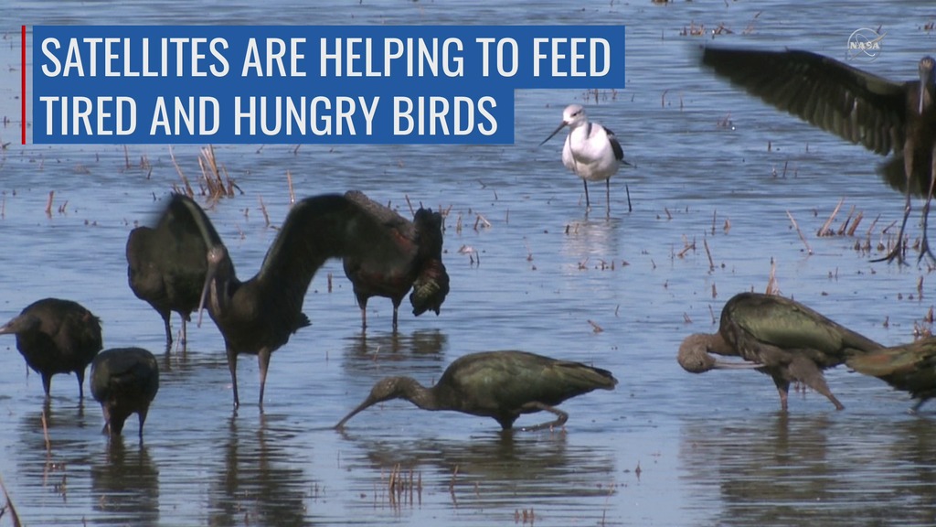
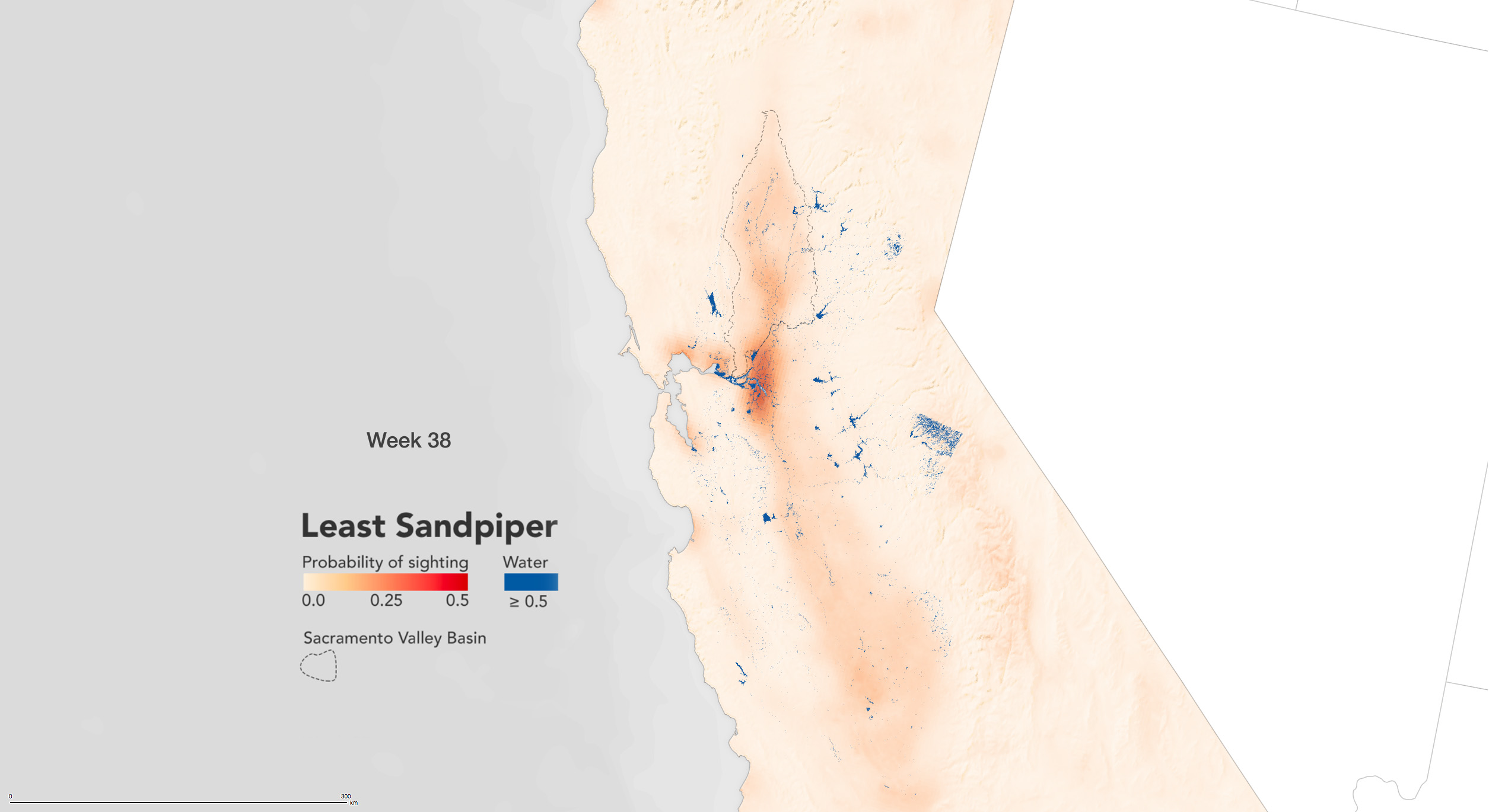
The BirdReturns program, created by The Nature Conservancy of California, is an effort to provide "pop-up habitats" for some of the millions of shorebirds, such as sandpipers and plovers, that migrate each year from their summer breeding grounds in Alaska and Canada to their winter habitats in California, Mexico, Central and South America. The route takes the birds along what’s called the Pacific Flyway, where they seek out the increasingly rare wetlands teeming with tasty insects to fuel their long-distance flights.
The Nature Conservancy of California operates the BirdReturns program, with partners including Point Blue Conservation Science, Audubon California and the Cornell Lab of Ornithology.
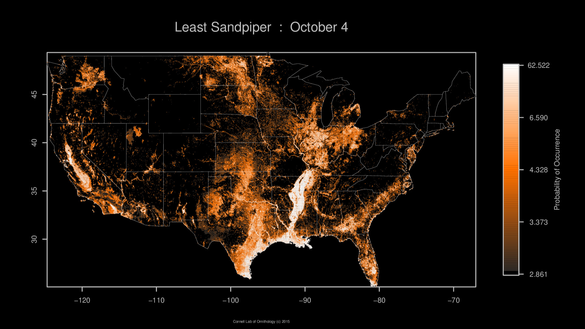
Over the last century, California's Central Valley has lost 95% of the wetlands habitat, which is needed for the shorebirds while on their migration. The solution involves big data, binoculars and rice paddies. The Cornell Lab of Ornithology’s eBird program collects on-the-ground observations, including species and date spotted, from bird watchers nationwide. With a recent NASA grant to Cornell, scientists created computer models to analyze that information and combine it with satellite remote sensing imagery from Landsat and the Moderate Resolution Imaging Spectroradiometer instruments on NASA’s Terra and Aqua satellites. With these models, they could identify areas in the Central Valley where birds flocked to during the spring and fall migrations, as well as estimate the number of birds making the journey.
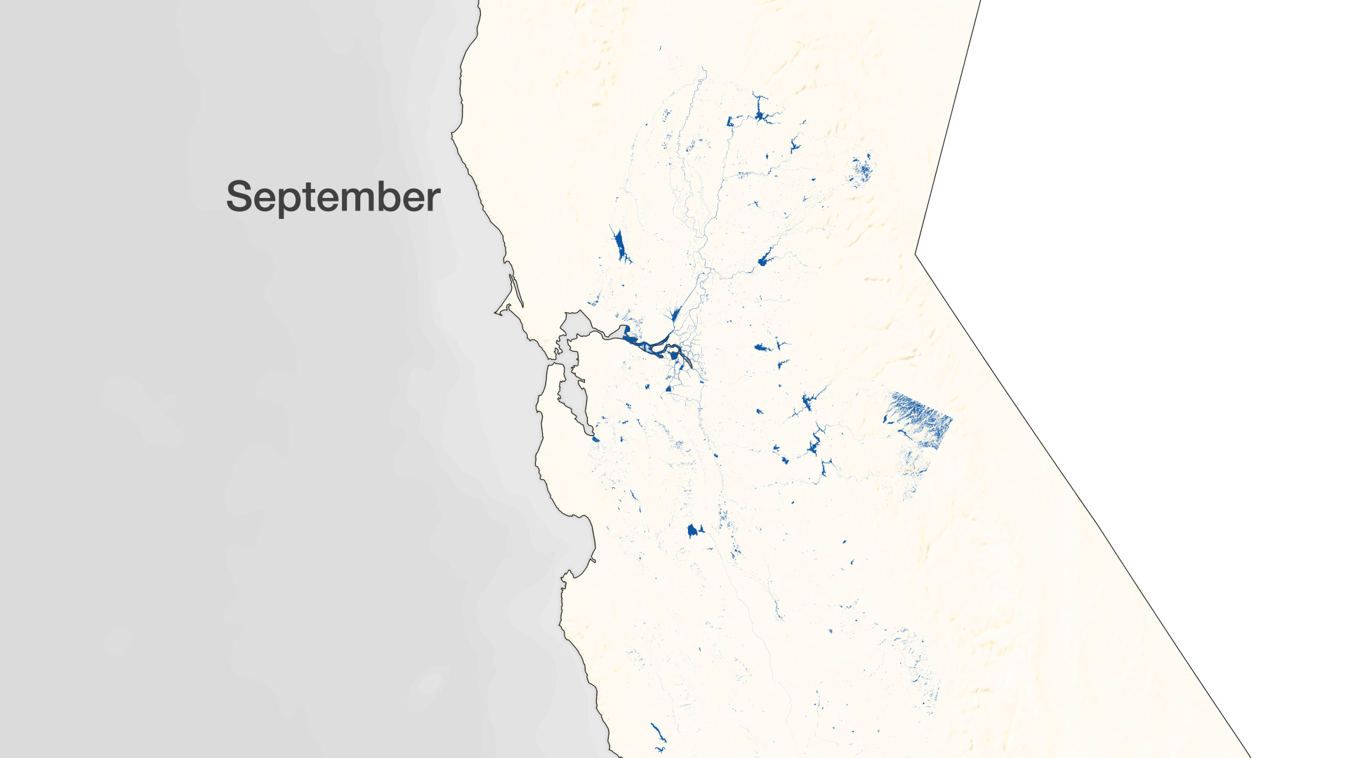
Some of his colleagues had been using Landsat images to look at where – and when – there was standing water, to assist with surveys of shorebirds. The nonprofit Point Blue, based in Petaluma, California, developed models that can classify habitats based on Landsat imagery. For the BirdReturns project, the team analyzed 1,500 Landsat scenes between 2000 and 2011, and then additional images from Landsat 8 after its 2013 launch. For each area not blocked by clouds, they classified whether there was surface water.
Matching the location and timing of surface water from Landsat with the route and timing of migrating shorebirds from eBird, the BirdReturns program looks for those key sites where extra water would make a difference for the birds, which forage for food in the wetland areas. The Nature Conservancy then uses a reverse auction where farmers try to submit the lowest bid to turn their empty fields into a pop-up wetland for the few weeks the birds are stopping in the Central Valley while on their migration.
We would like to thank the Point Blue and The Nature Conservancy for supplying Central Valley water data. Least sandpiper data courtesy of Cornell Lab of Ornithology, eBird Basic Dataset. Version: EBD_relMay-2013. Cornell Lab of Ornithology, Ithaca, New York. May 2013.
Landsat Helps Feed the Birds
The Nature Conservancy of California operates the BirdReturns program, with partners including Point Blue Conservation Science, Audubon California and the Cornell Lab of Ornithology.
Over the last century, California's Central Valley has lost 95% of the wetlands habitat, which is needed for the shorebirds while on their migration. The solution involves big data, binoculars and rice paddies. The Cornell Lab of Ornithology’s eBird program collects on-the-ground observations, including species and date spotted, from bird watchers nationwide. With a recent NASA grant to Cornell, scientists created computer models to analyze that information and combine it with satellite remote sensing imagery from Landsat and the Moderate Resolution Imaging Spectroradiometer instruments on NASA’s Terra and Aqua satellites. With these models, they could identify areas in the Central Valley where birds flocked to during the spring and fall migrations, as well as estimate the number of birds making the journey.
Some of his colleagues had been using Landsat images to look at where – and when – there was standing water, to assist with surveys of shorebirds. The nonprofit Point Blue, based in Petaluma, California, developed models that can classify habitats based on Landsat imagery. For the BirdReturns project, the team analyzed 1,500 Landsat scenes between 2000 and 2011, and then additional images from Landsat 8 after its 2013 launch. For each area not blocked by clouds, they classified whether there was surface water.
Matching the location and timing of surface water from Landsat with the route and timing of migrating shorebirds from eBird, the BirdReturns program looks for those key sites where extra water would make a difference for the birds, which forage for food in the wetland areas. The Nature Conservancy then uses a reverse auction where farmers try to submit the lowest bid to turn their empty fields into a pop-up wetland for the few weeks the birds are stopping in the Central Valley while on their migration.
We would like to thank the Point Blue and The Nature Conservancy for supplying Central Valley water data. Least sandpiper data courtesy of Cornell Lab of Ornithology, eBird Basic Dataset. Version: EBD_relMay-2013. Cornell Lab of Ornithology, Ithaca, New York. May 2013.
For More Information
Credits
Matthew R. Radcliff (USRA): Lead Producer
Kate Ramsayer (Telophase): Writer
Joshua Stevens (SSAI): Visualizer
Jeffrey Masek (NASA/GSFC): Scientist
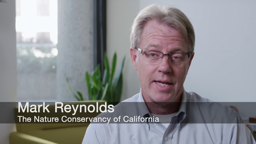
Mark Reynolds (Nature Conservancy of California): Scientist
Matt Reiter (Point Blue Conservation Science): Scientist
Steve Kelling (Cornell Lab of Ornithology): Scientist
Owen Bissell (Fast and Light Productions): Videographer
Scott Stender (Digit Video): Videographer
Laurence Bartone (Bartone Photography): Videographer
Joy Ng (USRA): Lead Producer
Kate Ramsayer (Telophase): Writer
Joshua Stevens (SSAI): Visualizer
Jeffrey Masek (NASA/GSFC): Scientist
Mark Reynolds (Nature Conservancy of California): Scientist
Matt Reiter (Point Blue Conservation Science): Scientist
Steve Kelling (Cornell Lab of Ornithology): Scientist
Owen Bissell (Fast and Light Productions): Videographer
Scott Stender (Digit Video): Videographer
Laurence Bartone (Bartone Photography): Videographer
Joy Ng (USRA): Lead Producer
Please give credit for this item to:
NASA's Goddard Space Flight Center
We would like to thank the Point Blue and The Nature Conservancy for supplying Central Valley water data.
Least sandpiper data courtesy of Cornell Lab of Ornithology, eBird Basic Dataset. Version: EBD_relMay-2013. Cornell Lab of Ornithology, Ithaca, New York. May 2013.
Short URL to share this page:
https://svs.gsfc.nasa.gov/12013
Mission:
Landsat
This item is part of these series:
Narrated Movies
Landsat
Goddard TV Tape:
G2015-070 -- Temporary Wetlands
Keywords:
SVS >> HDTV
DLESE >> Hydrology
GCMD >> Earth Science >> Biosphere >> Animal Taxonomy >> Birds
GCMD >> Earth Science >> Hydrosphere >> Surface Water >> Wetlands
NASA Science >> Earth
GCMD keywords can be found on the Internet with the following citation: Olsen, L.M., G. Major, K. Shein, J. Scialdone, S. Ritz, T. Stevens, M. Morahan, A. Aleman, R. Vogel, S. Leicester, H. Weir, M. Meaux, S. Grebas, C.Solomon, M. Holland, T. Northcutt, R. A. Restrepo, R. Bilodeau, 2013. NASA/Global Change Master Directory (GCMD) Earth Science Keywords. Version 8.0.0.0.0


