Earth
ID: 11529
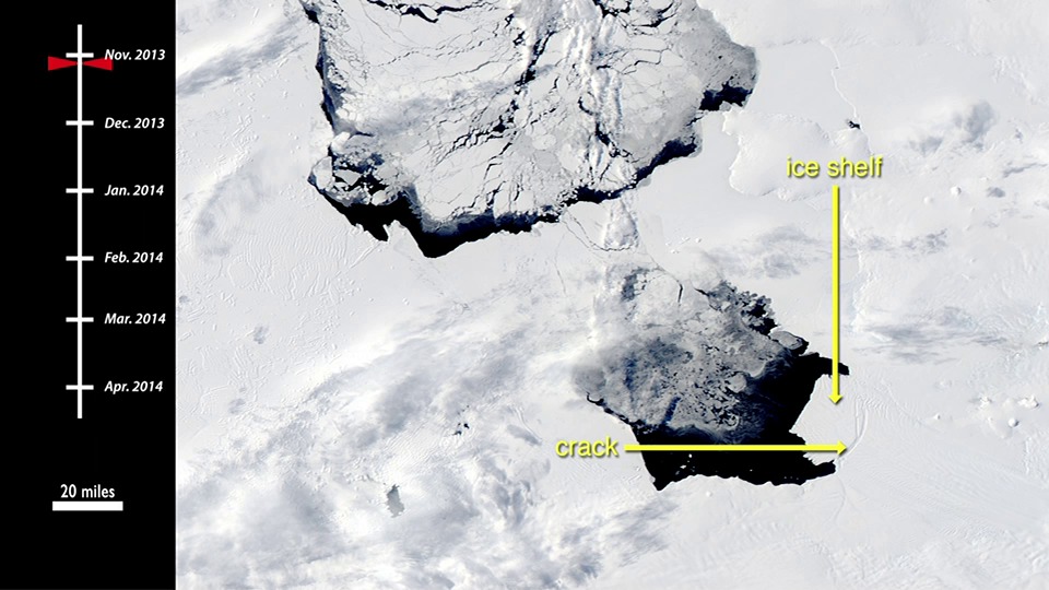
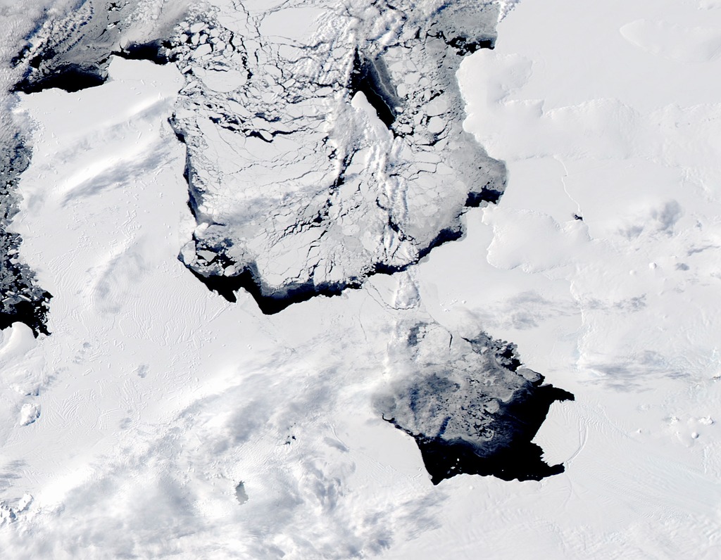
In early November 2013, a large iceberg separated from the front of Antarctica’s Pine Island Glacier. It thus began a journey across Pine Island Bay, a basin of the Amundsen Sea. The ice island, named B31, will likely be swept up soon in the swift currents of the Southern Ocean, though it will be hard to track visually for the next six months as Antarctica heads into winter darkness.
Over the course of five months in Antarctic spring and summer, the Moderate Resolution Imaging Spectroradiometer (MODIS)—an instrument on NASA’s Terra and Aqua satellites—captured a series of images of ice island B31. The time-lapse video below shows the motion of the massive chunk of ice.
The significance of the event is still being sorted out. “Iceberg calving is a very normal process,” noted Kelly Brunt, a glaciologist at NASA’s Goddard Space Flight Center. “However, the detachment rift, or crack, that created this iceberg was well upstream of the 30-year average calving front of Pine Island Glacier, so this a region that warrants monitoring.”
Pine Island Glacier has been the subject of intense study in the past two decades because it has been thinning and draining rapidly and may be one of the largest contributors to sea level rise.
Pine Island Glacier Ice Island 2013
Over the course of five months in Antarctic spring and summer, the Moderate Resolution Imaging Spectroradiometer (MODIS)—an instrument on NASA’s Terra and Aqua satellites—captured a series of images of ice island B31. The time-lapse video below shows the motion of the massive chunk of ice.
The significance of the event is still being sorted out. “Iceberg calving is a very normal process,” noted Kelly Brunt, a glaciologist at NASA’s Goddard Space Flight Center. “However, the detachment rift, or crack, that created this iceberg was well upstream of the 30-year average calving front of Pine Island Glacier, so this a region that warrants monitoring.”
Pine Island Glacier has been the subject of intense study in the past two decades because it has been thinning and draining rapidly and may be one of the largest contributors to sea level rise.
For More Information
Credits
Jesse Allen (Sigma Space Corporation): Lead Animator
Matthew R. Radcliff (USRA): Video Editor
Matthew R. Radcliff (USRA): Producer
Aaron E. Lepsch (ADNET Systems, Inc.): Project Support
Mike Carlowicz (Sigma Space Corporation): Writer
Matthew R. Radcliff (USRA): Video Editor
Matthew R. Radcliff (USRA): Producer
Aaron E. Lepsch (ADNET Systems, Inc.): Project Support
Mike Carlowicz (Sigma Space Corporation): Writer
Please give credit for this item to:
NASA's Earth Observatory
NASA's Earth Observatory
Short URL to share this page:
https://svs.gsfc.nasa.gov/11529
This item is part of this series:
Narrated Movies
Goddard TV Tape:
G2014-037 -- PIG Ice Island
Keywords:
SVS >> HDTV
SVS >> Pine Island Glacier
GCMD >> Earth Science >> Cryosphere >> Glaciers/Ice Sheets >> Ice Sheets
GCMD >> Earth Science >> Cryosphere >> Glaciers/Ice Sheets >> Icebergs
NASA Science >> Earth
GCMD keywords can be found on the Internet with the following citation: Olsen, L.M., G. Major, K. Shein, J. Scialdone, S. Ritz, T. Stevens, M. Morahan, A. Aleman, R. Vogel, S. Leicester, H. Weir, M. Meaux, S. Grebas, C.Solomon, M. Holland, T. Northcutt, R. A. Restrepo, R. Bilodeau, 2013. NASA/Global Change Master Directory (GCMD) Earth Science Keywords. Version 8.0.0.0.0


