Earth
ID: 10975

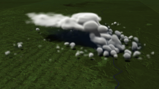
In the late 18th century, Count Rumford discovered the phenomenon of heat transfer in fluids—a process called convection—as he examined why some English desserts, such as apple pie, stay warm for so long. Convection as it pertains to atmospheric phenomena, however, is no pie-in-the-sky concept. Many clouds, including the puffy cumulus or more threatening cumulonimbus, get their start thanks to the rise of sun-warmed air and water vapor. Fortunately, scientists today have more tools at their disposal than in Rumford's day with which to study the characteristics of cloud evolution. The visualization below uses data from the NASA Goddard Cumulus Ensemble Model to simulate a thunderstorm that formed on February 23, 1999 in Rondonia, Brazil. Watch as clouds grow, rise, merge and give way to rain. The entire evolution typically lasts a few hours, but is accelerated in the video to be viewed in just under a minute.


Up, Up And Away
Related Story
Story Credits
Visualizer/Animator:
James W. Williams (GST)
Narrator:
Kathryn Hansen (Wyle Information Systems)
Producer:
Kayvon Sharghi (USRA)
Lead Scientists:
Wei-Kuo Tao (NASA/GSFC)
Stephen Lang (NASA/GSFC)
Lead Writer:
Kathryn Hansen (Wyle Information Systems)
James W. Williams (GST)
Narrator:
Kathryn Hansen (Wyle Information Systems)
Producer:
Kayvon Sharghi (USRA)
Lead Scientists:
Wei-Kuo Tao (NASA/GSFC)
Stephen Lang (NASA/GSFC)
Lead Writer:
Kathryn Hansen (Wyle Information Systems)
Please give credit for this item to:
NASA's Goddard Space Flight Center
Astronaut image STS41B-41-2347 was provided by the Earth Sciences and Image Analysis Laboratory at Johnson Space Center.
NASA's Goddard Space Flight Center
Astronaut image STS41B-41-2347 was provided by the Earth Sciences and Image Analysis Laboratory at Johnson Space Center.
Short URL to share this page:
https://svs.gsfc.nasa.gov/10975
Keywords:
DLESE >> Narrated
SVS >> App
NASA Science >> Earth
https://svs.gsfc.nasa.gov/10975
Keywords:
DLESE >> Narrated
SVS >> App
NASA Science >> Earth


