Earth
ID: 10853
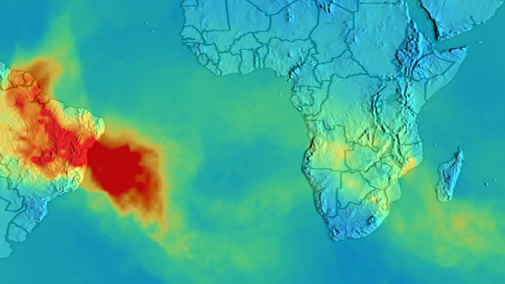
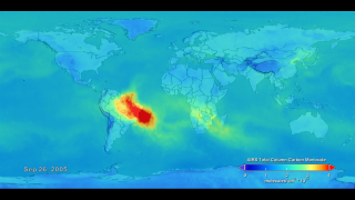
The slash-and-burn practices farmers use in parts of South America to clear land before planting in the spring added to a severe Amazon fire season in 2005. Dramatic increases in carbon monoxide were recorded over South America in August, September, and October of that year. But a satellite instrument also saw the fire emissions travel far beyond the continent. Plumes of the colorless, odorless gas, which can linger in the atmosphere up to three months, moved across the Atlantic Ocean and likely affected the air quality over Africa. Scientists measured this carbon monoxide path using an instrument called AIRS onboard NASA's Aqua satellite. AIRS was designed to measure water vapor, clouds, and air and land temperatures. Once it was launched, scientists realized they could use it to make global carbon monoxide and carbon dioxide measurements, providing unprecedented global views of greenhouse gas distributions in the atmosphere. Watch in the visualization below how AIRS saw carbon monoxide fire emissions sweep out over the Atlantic Ocean, above Africa, toward the Indian Ocean and all the way to Australia.


Following The Carbon Monoxide Trail
Related Story
Story Credits
Lead Visualizer/Animator:
Lori Perkins (NASA/GSFC)
Lead Scientists:
Tom Pagano (NASA/JPL CalTech)
Edward Olsen (NASA/JPL CalTech)
Hai Nguyen (California Institute of Technology)
Lead Writer:
Alison Schuyler Ogden (NASA/GSFC)
Lori Perkins (NASA/GSFC)
Lead Scientists:
Tom Pagano (NASA/JPL CalTech)
Edward Olsen (NASA/JPL CalTech)
Hai Nguyen (California Institute of Technology)
Lead Writer:
Alison Schuyler Ogden (NASA/GSFC)
Please give credit for this item to:
NASA's Goddard Space Flight Center
Image of Amazon rainforest fires captured from space courtesy of the Image Science & Analysis Laboratory, NASA Johnson Space Center.
NASA's Goddard Space Flight Center
Image of Amazon rainforest fires captured from space courtesy of the Image Science & Analysis Laboratory, NASA Johnson Space Center.
Short URL to share this page:
https://svs.gsfc.nasa.gov/10853
Keywords:
SVS >> App
NASA Science >> Earth
https://svs.gsfc.nasa.gov/10853
Keywords:
SVS >> App
NASA Science >> Earth


