HS3 Campaign
Overview
The Hurricane and Severe Storm Sentinel (HS3) is a five-year mission specifically targeted to investigate the processes that underlie hurricane formation and intensity change in the Atlantic Ocean basin. The NASA Global Hawk UASs are ideal platforms for investigations of hurricanes, capable of flight altitudes greater than 55,000 ft and flight durations of up to 30 h. HS3 will utilize two Global Hawks, one with an instrument suite geared toward measurement of the environment and the other with instruments suited to inner-core structure and processes.
Data Visualizations
- ID: 4210 Visualization
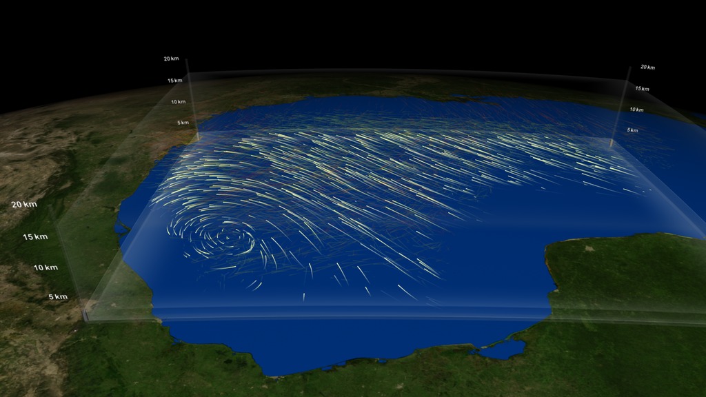
HS3 Global Hawk Observes winds from tropical depression A95L in September 2013
Go to this pageThis visualization shows wind flows from Tropical Depression A95L in the Gulf of Mexico between September 19 and 20 of 2013. The wind field was derived from data returned from dropsondes. The color of the winds represents altitude where ground-level winds are shown in white. Higher altitude winds, around 10km, are shown in orange and the highest altitude winds, around 15 km, are shown in red.These dropsondes are probes that were dropped from the Global Hawk unmanned vehicle (part of the Hurricane and Severe Storm Sentinel project, HS3) as it flew in a lawnmower-like pattern over the storm. As the dropsonde probes fell through the atmosphere, atmospheric measurements including wind direction are recorded. Wind direction data from 88 different dropsondes were merged to create a single, derived flow field. The visualization shows particles moving through the flow field. The atmosphere is exaggerated 10 times to help differentiate various levels of the atmosphere. Only a thin slice of the atmosphere is shown at any given time, represented by a moving horizontal window. Lower level winds show the cyclonic circulation associated with the tropical disturbance. But, just above those cyclonic winds, the storm is thwarted by wind shear, prohibiting further development into a tropical cyclone. NASA scientists use data from unmanned aircraft to better understanding why some storms develop into hurricanes and others do not. ||
- ID: 4102 Visualization
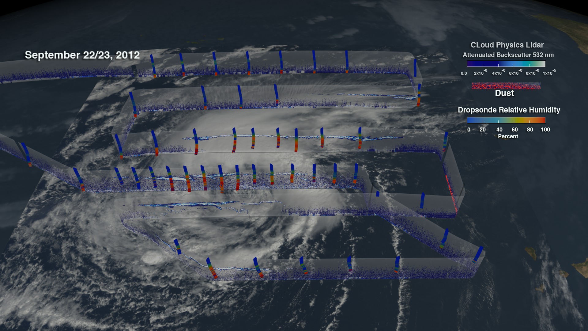
Global Hawk observes the Saharan Air Layer through the Cloud Physics Lidar (CPL) during Hurricane Nadine
Go to this pageNASA's Hurricane and Severe Storm Sentinel mission(HS3) is a mission that brings together several NASA centers with federal and university partners to investigate the processes that underlie hurricane formation and intensity change in the Atlantic Ocean basin. Among those factors, HS3 will address the controversial role of the hot, dry and dusty Saharan Air Layer(SAL) in tropical storm formation and intensification and the extent to which deep convection in the inner-core region of storms is a key driver of intensity change.One instrument used to investigate the SAL is the cloud physics lidar(CPL). CPL uses a laser to measure vertical profiles of dust; a dropsonde system that releases small instrumented packages from the aircraft that fall to the surface while measuring profiles of temperature, humidity, and winds; and an infrared sounder that measures temperature and humidity in clear-sky regions.The CPL is an airborne lidar system designed specifically for studying clouds and aerosols. CPL will study cloud- and dust-layer boundaries and will provide optical depth or thickness of aerosols and cloudsOn Sept. 11 and 12, during the 2012 HS3 mission, the NASA Global Hawk aircraft covered more than one million square kilometers (386,100 square miles) going back and forth over the storm in a gridded fashion in what's called a "lawnmower pattern."Dropsonde data from HS3's flights show temperature and humidity conditions in the storm. In this movie, the dropsondes are colored with the relative humidity data where blue represents dry air and red represents moist air.For more information about NASA's HS3 mission, visit:http://www.nasa.gov/hs3 ||
- ID: 4035 Visualization
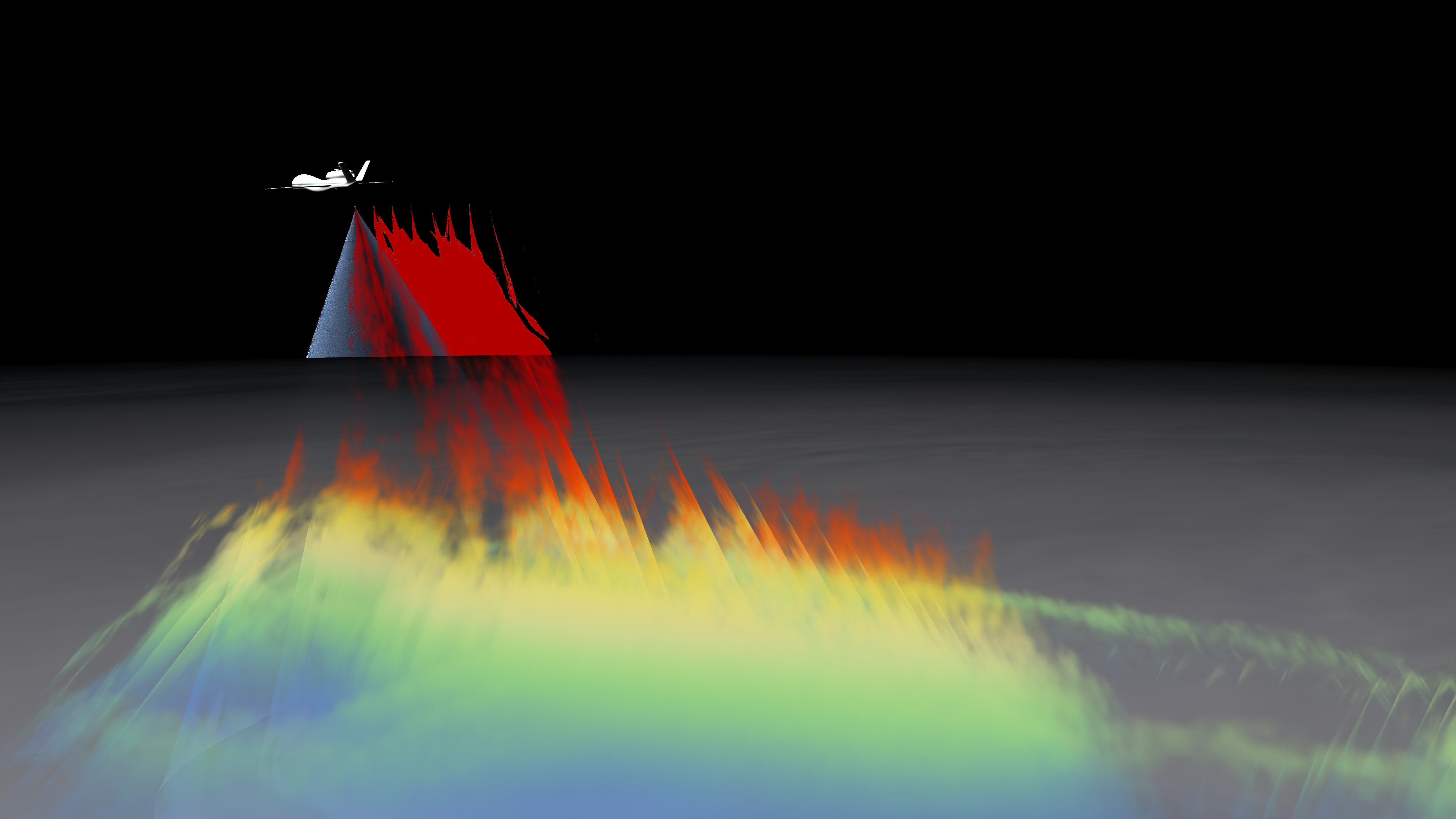
High Altitude Imaging Wind and Rain Profiler(HIWRAP) onboard the Genesis and Rapid Intensification Processes(GRIP) Experiment monitors Eye Wall Development
Go to this pageWind measurements are crucial for understanding and forecasting tropical storms since they are closely tied to the overall dynamics of the storm. The dual-wavelength (Ku and Ka band) High-Altitude Imaging Wind and Rain Airborne Profiler (HIWRAP) flew for the first time on the Global Hawk Unmanned Aerial Vehicle (UAV) during the 2010 Genesis and Rapid Intensification Processes (GRIP).The HIWRAP is able to measure line-of-sight and ocean surface winds for a longer period of time than obtained by current satellites and lower-altitude instrumented aircraft. HIWRAP is conical scanning, and winds and reflectivity can be mapped within the swath below the Global Hawk. HIWRAP utilizes solid state transmitters along with a novel pulse compression scheme. This results in a system that is considerably more compact in size, requires less power, and ultimately costs significantly less than typical radars currently in use for clouds and precipitation observation. HIWRAP is able to image the winds through volume backscattering from clouds and precipitation, enabling it to measure the tropospheric winds above heavy rain at high levels. The first interesting case from the HIWRAP flights were the rapid intensification of Hurricane Karl on September 16 and 17, 2010. This visual will highlight the precipitation structure of this storms during their intensification as derived from the HIWRAP KU observations. Please note, the dimensions of the Global Hawk were exaggerated by a factor of 10 so the viewer could see the UAV. The Global Hawk actual dimensions are 44.4 ft (13.5 m) length by 116.2 ft. (35.4 m) wingspan by 15.2 ft (4.6 m) height. The movie starts as the Global Hawk flies over Hurricane Karl to reveal a Hot Tower. Hot towers are important to understanding hurricane intensification because they can carry hot moist air through the high layer of cirrus clouds above a hurricane. Hot towers are hard to study because they go so high and they do not last very long. In this movie, several of the paths have been placed in storm-centered coordinates and laid together to reveal the storm's hot towers and eyewall development. The structure of this storm is seen through reflectivity data where dbz is between 25 and 40.The HIWRAP data is colored based on the height. Red is 12 km, orange is 10 km, yellow is 7.5 km, green is 6 km, and blue is under 6 km.More information on GRIP and other elements of NASA's Hurricane and Severe Storm Sentinel project visit http://www.nasa.gov/HS3. ||
- ID: 4036 Visualization
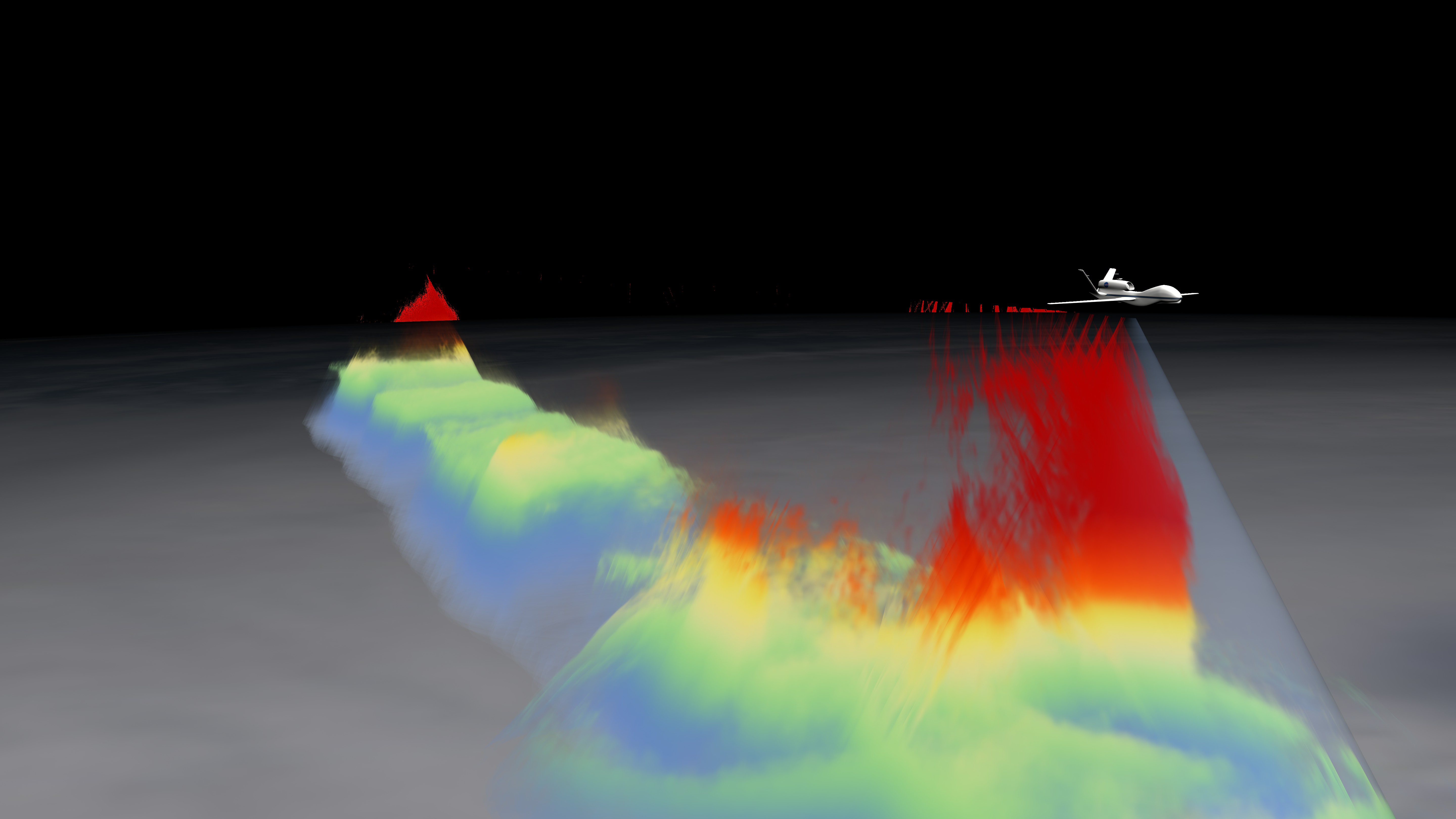
Global Hawk Takes High Altitude Imaging Wind and Rain Airborne Profiler (HIWRAP) Data
Go to this pageThe dual-wavelength (Ku- and Ka-band) High Altitude Imaging Wind and Rain Airborne Profiler (HIWRAP) flew for the first time on the Global Hawk Unmanned Aerial Vehicle (UAV) during the 2010 Genesis and Rapid Intensification Processes (GRIP). The HIWRAP is able to measure line-of-sight and ocean surface winds for a longer period of time than obtained by current satellites and lower-altitude instrumented aircraft. HIWRAP is conical scanning, and winds and reflectivity can be mapped within the swath below the Global Hawk. This visual will highlight the UAV measuring Hurricane Karl's HIWRAP Ku-band observations on September 16 from 18:53:10 through 19:19:18. The dimensions of the Global Hawk were exaggerated by a factor of 10 so the viewer could see the UAV. The Global Hawk actual dimensions are 44.4 ft (13.5 m) length by 116.2 ft. (35.4 m) wingspan by 15.2 ft (4.6 m) height. The movie starts as the Global Hawk flies over Hurricane Karl to reveal a hot tower. Hot towers are important to understanding hurricane intensification because they can carry hot moist air through the high layer of cirrus clouds above a hurricane. Hot towers are hard to study because they go so high and they do not last very long. The structure of this storm is seen through reflectivity data where dbz is between 25 and 40. The HIWRAP data is colored based on the height from the surface. Red shows 12 km above sea level, orange is 10 km, yellow is 7.5 km, green is 6 km, and blue is under 6 km.For more information on GRIP and other elements of NASA's Hurricane and Severe Storm Sentinel project, visit http://www.nasa.gov/HS3. ||
Produced Videos
- ID: 11669 Produced Video
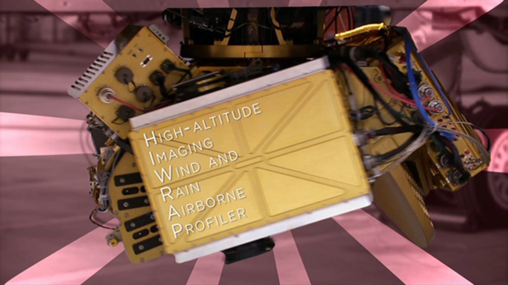
HIWRAP Instrument
Go to this pageThe HIWRAP is the High-Altitude Imaging Wind and Rain Airborne Profiler, a "conically scanning" Doppler radar, meaning it scans in a cone-shaped manner. Wind measurements are crucial for understanding and forecasting tropical storms since they are closely tied to the overall dynamics of the storm. The HIWRAP instrument is able to measure line-of-sight (along the radar beam) and because it scans in a cone beneath the aircraft, it gets two looks at most parts of the storm, allowing calculations of the 3-dimensional wind and rain fields. In the absence of rain, it can also measure ocean surface winds. ||
- ID: 11657 Produced Video
HS3: Cloud Physics Lidar
Go to this pageA short video about the Cloud Physics Lidar instrument onboard the HS3 Global Hawk aircraft.For complete transcript, click here. || CPL_Final_nasaportal00452_print.jpg (1024x576) [52.1 KB] || CPL_Final_nasaportal_print.jpg (1024x576) [55.3 KB] || CPL_Final_nasaportal_thm.png (80x40) [4.3 KB] || CPL_Final_nasaportal_web.png (320x180) [47.9 KB] || CPL_Final_nasaportal_searchweb.png (320x180) [47.9 KB] || CPL_Final_prores.mov (1280x720) [2.4 GB] || CPL_Final_appletv_subtitles.m4v (960x540) [69.7 MB] || CPL_Final_720x480.webmhd.webm (960x540) [30.9 MB] || CPL_Final_appletv.m4v (960x540) [69.8 MB] || CPL_Final_1280x720.wmv (1280x720) [74.4 MB] || CPL_Final_youtube_hq.mov (1280x720) [122.9 MB] || CPL_Final_720x480.wmv (720x480) [61.2 MB] || CPL_Final_ipod_lg.m4v (640x360) [28.1 MB] || CPL_Final_nasaportal.en_US.vtt [3.2 KB] || CPL_Final_nasaportal.en_US.srt [3.2 KB] || CPL_Final_nasaportal.mov (640x360) [62.4 MB] || CPL_Final_ipod_sm.mp4 (320x240) [14.5 MB] ||
- ID: 11559 Produced Video
HS3: Global Hawks Soar into Storms
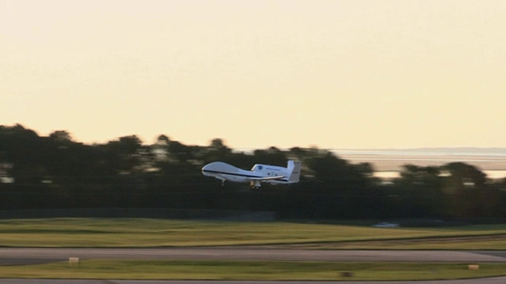
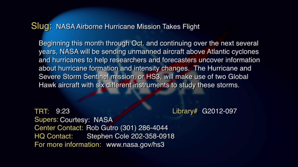
Go to this pageDuring this year's Atlantic hurricane season, NASA is redoubling its efforts to probe the inner workings of hurricanes and tropical storms with two unmanned Global Hawk aircraft flying over storms and two new space-based missions.NASA's airborne Hurricane and Severe Storm Sentinel or HS3 mission will revisit the Atlantic Ocean for the third year in a row. HS3 is a collaborative effort that brings together several NASA centers with federal and university partners to investigate the processes that underlie hurricane formation and intensity change in the Atlantic Ocean basin. The flights from Wallops Flight Facility in Virginia take place between Aug. 26 and Sept. 29 during the peak of the Atlantic hurricane season which runs from June 1 to Nov. 30. ||
- ID: 11334 Produced Video
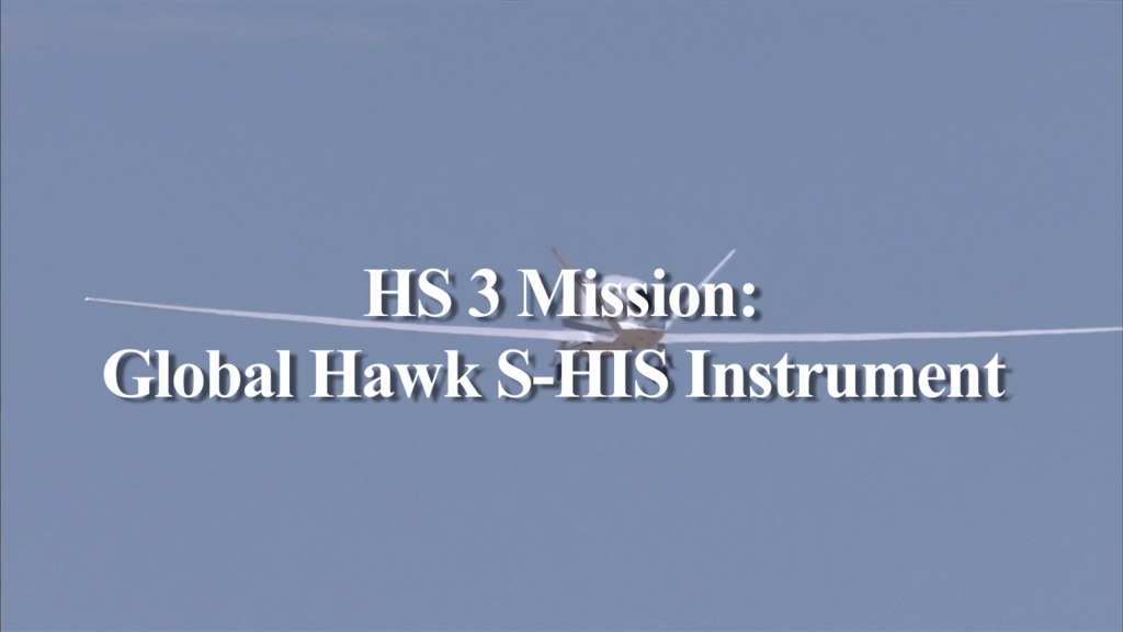
NASA's HS3 Mission: S-HIS Instrument
Go to this pageInterview with Henry "Hank" Revercomb, principal investigator for the NASA HS3 Mission's Scanning High-Resolution Interferometer Sounder Instrument. He is responsible for the infrared remote sensing of temperature, water vapor, and cloud fields from the Global Hawk aircraft monitoring the environment of hurricanes to help understand mechanisms for intensity changes. He is also the Director of University of Wisconsin-Madison's Space Science and Engineering Center. ||
- ID: 11312 Produced Video
NASA's HS3 Mission: The Dropsonde System
Go to this pageDropsondes provide insight into hurricane strength by monitoring winds and their direction. They also measure temperature, pressure, and humidity in the atmosphere. NOAA physicist Gary Wick describes the Dropsonde System on board NASA's Global Hawk aircraft. For more information: www.nasa.gov/HS3 ||
Interviews and Raw Footage
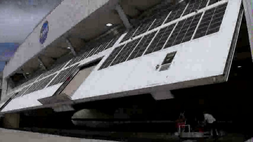
- ID: 11666 Produced Video
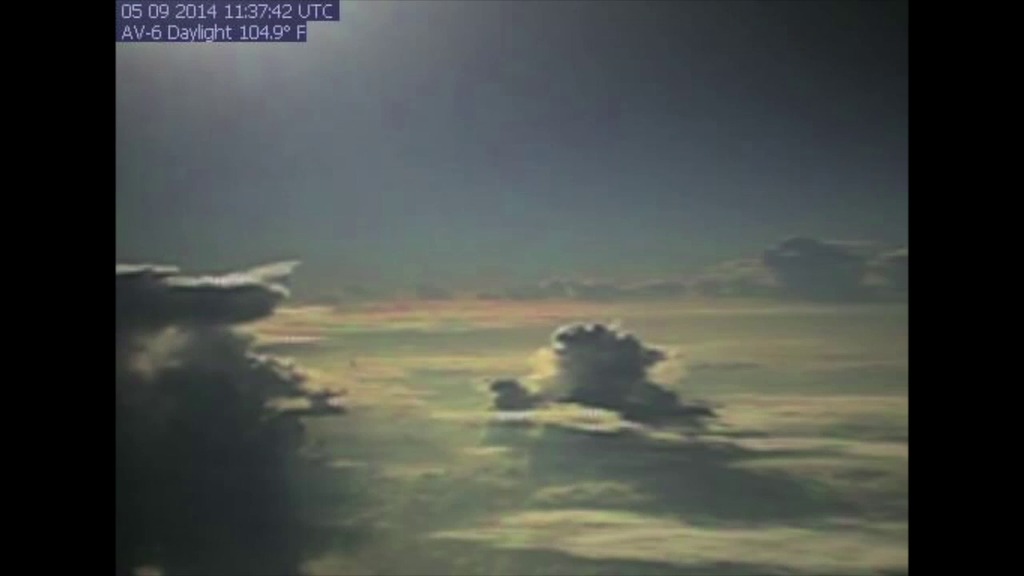
HS3 Global Hawk Camera Timelapse
Go to this pageNASA released a time-lapse video that highlights three different cameras aboard NASA's remotely piloted Global Hawk aircraft No. 872 as it investigated two tropical systems in the Atlantic Ocean in early September 2014. The 2 minute and 40 second time lapse was created by Dave Fratello, HS3 payload manager of the NASA Global Hawk project at NASA's Armstrong Flight Research Center in Edwards, California. The video highlights the imaging from the daylight, HDVis or high-definition Visualization camera and low light camera. The video begins using the daylight camera and shows the Global Hawk taking off from NASA's Wallops Flight Facility runway in Virginia. ||
- ID: 11039 Produced Video
HS3 video resources and interview clips
Go to this pageThe Hurricane and Severe Storm Sentinel (HS3) is a five-year mission specifically targeted to investigate the processes that underlie hurricane formation and intensity change in the Atlantic Ocean basin. The NASA Global Hawk UASs are ideal platforms for investigations of hurricanes, capable of flight altitudes greater than 55,000 ft and flight durations of up to 30 h. HS3 will utilize two Global Hawks, one with an instrument suite geared toward measurement of the environment and the other with instruments suited to inner-core structure and processes. ||