Lunar Topography: ULCN versus LOLA
This animation illustrates the dramatic improvement in our knowledge of the Moon's terrain made possible by the Lunar Orbiter Laser Altimeter (LOLA) instrument onboard the Lunar Reconnaissance Orbiter (LRO) spacecraft. A LOLA digital elevation map compiled in late 2009 is compared to the Unified Lunar Control Network (ULCN) 2005, a painstakingly constructed map based on the best available data at the time, including imagery from the Clementine, Apollo, Mariner 10, and Galileo missions as well as Earth-based observations.
The height of the terrain is color-coded, with blues and greens representing low altitudes and reds representing high altitudes. The LOLA data used to create this media is available to the public in the LOLA archive of the PDS Geosciences node.
Globes showing lunar elevation data from 2005 (ULCN) and 2010 (LOLA) rotate side-by-side for comparison.
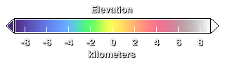
Elevation key. Elevations are relative to a mean radius of 1737.4 kilometers.

LOLA near hemisphere: A full-globe view of the near (Earth-facing) side of the Moon showing color-coded elevations, with alpha channel, using LOLA data.
LOLA far hemisphere: A full-globe view of the far side of the Moon (facing away from Earth) showing color-coded elevations, with alpha channel, using LOLA data.
ULCN near hemisphere: A full-globe view of the near (Earth-facing) side of the Moon showing color-coded elevations, with alpha channel, using data from ULCN 2005.
ULCN far hemisphere: A full-globe view of the far side of the Moon (facing away from Earth) showing color-coded elevations, with alpha channel, using ULCN 2005.
Credits
Please give credit for this item to:
NASA/Goddard Space Flight Center Scientific Visualization Studio
-
Animator
- Ernie Wright (UMBC)
-
Producer
- Andrew Freeberg (NASA/GSFC)
-
Scientist
- John Keller (NASA/GSFC)
Release date
This page was originally published on Tuesday, June 22, 2010.
This page was last updated on Wednesday, May 3, 2023 at 1:54 PM EDT.
Missions
This visualization is related to the following missions:Series
This visualization can be found in the following series:Datasets used in this visualization
-
ULCN 2005 (Unified Lunar Control Network 2005)
ID: 553The ULCN 2005 (Unified Lunar Control Network 2005) is a lunar control point network that precisely measured 272,931 pieces of data produced by the USGS using existing lunar imagery or data from the Clementine and other observations.
See all pages that use this dataset -
DEM (Digital Elevation Map) [LRO: LOLA]
ID: 653
Note: While we identify the data sets used in these visualizations, we do not store any further details, nor the data sets themselves on our site.