LOLA Lunar Topography in False Color
This animation is a brief tour of several prominent features of the Moon's terrain: Tycho crater, the south pole, and the South Pole-Aitken basin. The height of the terrain is color-coded, with blues and greens representing low altitudes and reds representing high altitudes. The view is match-moved to a companion piece showing the Moon in natural colors.
This is an update of animation 3582, which was produced before the launch of Lunar Reconnaissance Orbiter. Except for the Tycho crater inset, the elevation map in this updated version is based entirely on early results of the Lunar Orbiter Laser Altimeter onboard LRO. These results already represent a substantial improvement in our knowledge of the Moon's topography.
Moon false color topography flyover.
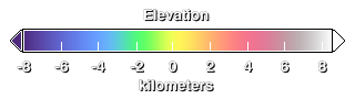
Elevation key.

Tycho crater and its bright ejecta rays are among the youngest and most recognizable features on the Moon. The crater is 85 kilometers (50 miles) wide and 4700 meters (15,400 feet) deep. The central peak is 2400 meters (7900 feet) above the crater floor.
Bowl-shaped Shackleton crater (center) marks the south pole of the Moon. It is flanked on the left by (top to bottom) Faustini, Shoemaker, and Haworth craters. Cabeus (bottom, center-left) was the site of the LCROSS impact.
The South Pole-Aitken basin, roughly 2100 kilometers (1300 miles) wide and 10 kilometers (6 miles) deep, is one of the largest impact features in the solar system. It lies on the far side of the Moon, the hemisphere never visible from Earth, and was found only after spacecraft began visiting the Moon in the 1960s.
For More Information
Credits
Please give credit for this item to:
NASA/Goddard Space Flight Center Scientific Visualization Studio
-
Animators
- Ernie Wright (UMBC)
- Marte Newcombe (Global Science and Technology, Inc.)
-
Producer
- Andrew Freeberg (NASA/GSFC)
-
Scientist
- James Garvin (NASA/GSFC)
Release date
This page was originally published on Friday, June 11, 2010.
This page was last updated on Wednesday, May 3, 2023 at 1:54 PM EDT.
Missions
This visualization is related to the following missions:Series
This visualization can be found in the following series:Datasets used in this visualization
-
750-nm Basemap [Clementine: UVVIS Camera]
ID: 545 -
Tycho DEM
ID: 551Margot et al.
This dataset can be found at: http://ieeexplore.ieee.org/stamp/stamp.jsp?arnumber=00841991
See all pages that use this dataset -
DEM (Digital Elevation Map) [LRO: LOLA]
ID: 653
Note: While we identify the data sets used in these visualizations, we do not store any further details, nor the data sets themselves on our site.