Groundwater Depletion in India Revealed by GRACE
Scientists using data from NASA's Gravity Recovery and Climate Experiment (GRACE) have found that the groundwater beneath Northern India has been receding by as much as one foot per year over the past decade. After examining many environmental and climate factors, the team of hydrologists led by Matt Rodell of NASA's Goddard Space Flight Center, Greenbelt, Md. concluded that the loss is almost entirely due to human consumption.
Groundwater comes from the natural percolation of precipitation and other surface waters down through Earth's soil and rock, accumulating in aquifers - cavities and layers of porous rock, gravel, sand, or clay. In some subterranean reservoirs, the water may be thousands to millions of years old; in others, water levels decline and rise again naturally each year. Groundwater levels do not respond to changes in weather as rapidly as lakes, streams, and rivers do. So when groundwater is pumped for irrigation or other uses, recharge to the original levels can take months or years.
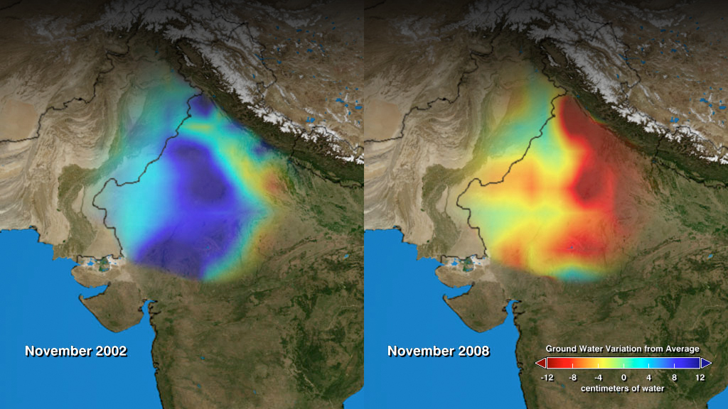
More than 109 cubic km (26 cubic miles) of groundwater disappeared from the region's aquifers between 2002 and 2008 — double the capacity of India's largest surface water reservoir, the Upper Wainganga, and triple that of Lake Mead, the largest manmade reservoir in the U.S.
The animation shown here depicts the change in groundwater levels as measured each November between 2002 to 2008.
Groundwater depletion, with color bar
This video is also available on our YouTube channel.
Groundwater depletion, without color bar

Colorbar
Dates
Credits
Please give credit for this item to:
NASA/Goddard Space Flight Center Scientific Visualization Studio
-
Animator
- Trent L. Schindler (UMBC)
-
Scientist
- Matthew Rodell (NASA/GSFC)
Release date
This page was originally published on Wednesday, August 12, 2009.
This page was last updated on Wednesday, November 15, 2023 at 12:00 AM EST.
Tapes
This visualization originally appeared on the following tapes:-
NASA Satellites Unlock Secret to Northern India's Vanishing Water
(ID: 2009078)
Wednesday, August 19, 2009 at 4:00AM
Produced by - Tom Biddlecome (Raytheon)
Related
- ID: 10764
 Produced Video