CALIPSO Profile over China, India and Bhutan
Aerosols, small particles in the atmosphere, can be produced from natural sources, such as volcanos and dust storms, or from human activity, such as pollution from manufacturing and automobiles. Aerosols remain in the atmosphere for long periods and travel across the globe propelled by winds. They also affect weather and climate by reflecting or absorbing sunlight and by altering chemical reactions within the atmosphere. The CALIOP lidar onboard the CALIPSO satellite enables scientists to collect aerosol data on slices or 'curtains' through the atmosphere. In these images looking east across India over the Himalayan Mountains and Bangladesh, slices of total attenuated backscatter show the geographic location and altitude of both aerosols and subvisible clouds in the upper troposphere. The curtain shown here extends from sea level to a height of 20 km. Both the height of the curtain and the terrain are exaggerated by 6x.

This image is a wide-angle view of the profile of CALIPSO total attenuated backscatter from 2006-06-15. The view is looking eastward over the Himalayan Mountains and eastern India. The near- vertical line marks the 30 degree north latitude while the horizontal line marks 90 degree east longitude.
This image is a close-up view of the profile of CALIPSO total attenuated backscatter from 2006-06-15. The view is looking eastward over the Himalayan Mountains.
This image is a close-up view of the profile of CALIPSO total attenuated backscatter from 2006-06-15. The view is looking eastward over eastern India. The Himalayan Mountains are on the left. The near- vertical line along the left-hand side marks the 30 degree north latitude.
This image shows another close-up view of the profile of CALIPSO total attenuated backscatter from 2006-06-15. The view is looking eastward over eastern India. The Himalayan Mountains are on the left. The near- horizontal line in the foreground marks the 90 degree east longitude.
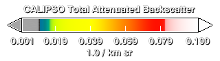
This color bar used to map the total attenuated backscatter is semi-transparent black for small values less than 0.01. All other values are opaque.
Credits
Please give credit for this item to:
Pat Lucker (NASA/LaRC)
NASA/Goddard Space Flight Center Scientific Visualization Studio
The Blue Marble data is courtesy of Reto Stockli (NASA/GSFC).
-
Visualizer
- Cindy Starr (Global Science and Technology, Inc.)
-
Scientist
- Charles Trepte (NASA/LaRC)
Release date
This page was originally published on Thursday, August 3, 2006.
This page was last updated on Wednesday, May 3, 2023 at 1:55 PM EDT.
Missions
This visualization is related to the following missions:Datasets used in this visualization
-
Total Attenuated Backscatter [CALIPSO: CALIOP]
ID: 583
Note: While we identify the data sets used in these visualizations, we do not store any further details, nor the data sets themselves on our site.