Wildfire Growth around Yellowstone National Park in 1988 (WMS)
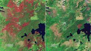
During the summer of 1988, wildfires burned about 1.4 million acres in and around Yellowstone National Park. Spurred by the driest summer in park history, the fires started in early July and lasted until early October. The worst day was August 20, when tremendous winds pushed the fires to burn over 150,000 acres. Although the scars from these fires are still visible in Landsat imagery from space over ten years later, the patchwork nature of the fire footprint left many unburned areas from which plant species have regenerated very successfully. This animation shows how the fires progressed in the period from June 30 though October 2, 1988, by which time the fall rain and snow had stopped the fire growth. These maps are based on daily ground observations by fire lookouts in the park and by infrared imaging cameras flown over the park at night. These observations are considered accurate to within about 100 meters.
This animation shows the progression of the fires in and around Yellowstone National Park during the summer of 1988, overlayed on a false-color image from Landsat 7. Independent fires are shown in different colors, and the most recently burned areas are shown in a brighter color.
This product is available through our Web Map Service.
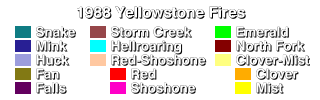
This is the legend for the Yellowstone Fires animation, identifying the names of the fire regions.
For More Information
Credits
Please give credit for this item to:
NASA/Goddard Space Flight Center
Scientific Visualization Studio
-
Animators
- Eric Sokolowsky (Global Science and Technology, Inc.)
- Horace Mitchell (NASA/GSFC)
- Steve Maher (NASA/GSFC)
-
Scientist
- Robert Stevens (USGS)
Release date
This page was originally published on Friday, February 13, 2004.
This page was last updated on Sunday, November 12, 2023 at 10:00 PM EST.
Missions
This visualization is related to the following missions:Series
This visualization can be found in the following series:Datasets used in this visualization
-
[Landsat-7: ETM+]
ID: 55This dataset can be found at: http://landsat.gsfc.nasa.gov/about/wrs.html
See all pages that use this dataset -
Fire Perimeters
ID: 273This dataset can be found at: http://sagemap.wr.usgs.gov/ftp/wyoming/NPS/yell_fire88perim.htm
See all pages that use this dataset
Note: While we identify the data sets used in these visualizations, we do not store any further details, nor the data sets themselves on our site.
Related
- ID: 10864
 Produced Video