A Map of Freshwater

Fifteen years of satellite data show changes in freshwater around the world.
Freshwater is found in lakes, rivers, soil, snow, groundwater and ice, and is one of the most essential of Earth's resources, for drinking water and agriculture. However, the distribution of freshwater around the planet is changing. Researchers used a pair of satellites called the Gravity Recovery and Climate Experiment, or GRACE, to track freshwater movement over the last fifteen years. The twin GRACE satellites were launched in 2002 as a joint mission between NASA and the German Aerospace Center (DLR). The two satellites precisely measured the distance between themselves to detect changes in Earth's gravity field caused by movements of mass on the planet below, caused by shifts in water and ice. They found that some regions' water supplies are relatively stable, others experienced increases or decreases. Climate change has driven freshwater loss from the ice sheets at the poles, which has implications for sea level rise. Other areas saw groundwater depletions because of humans using water for irrigating crops or increases due to higher amounts of rainfall because of natural variability. Watch the video to learn more.
NASA satellite observations combined with maps of human activities show where freshwater levels are changing and why.
The researchers found that a combination of natural and human pressures can lead to complex scenarios in some regions.
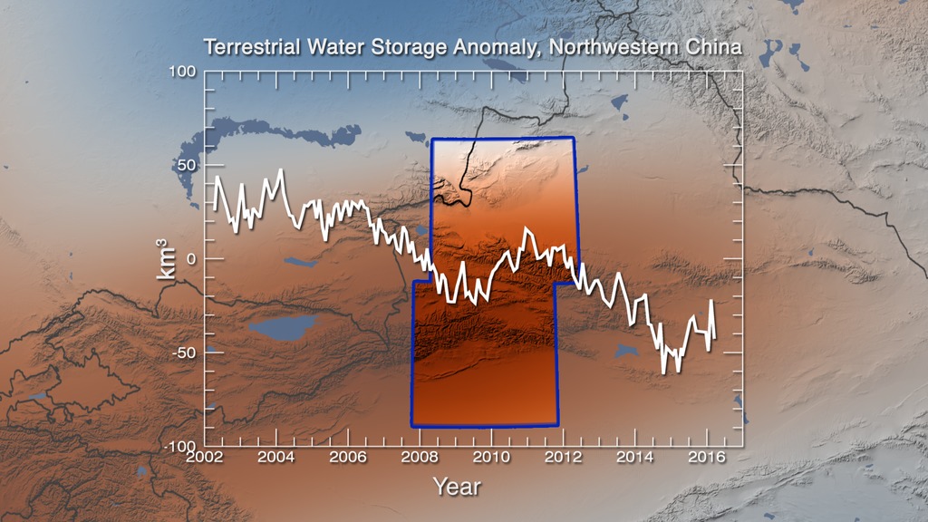
In northwestern China, freshwater is complex with glaciers, rivers, agriculture, and groundwater. Overall it shows a loss of freshwater.
The Okavango Delta shows an increase in freshwater between 2002 and 2010, likely due to natural variability.
A true color satellite image of California shows drought in the region which corresponds with decreases in freshwater reserves.
In spring 2018, NASA launched a satellite pair, GRACE Follow-On, to continue studying water movement around the planet.
For More Information
See NASA.gov
Credits
Please give credit for this item to:
NASA's Scientific Visualization Studio
-
Animator
- Trent L. Schindler (USRA)
-
Producer
- Kathryn Mersmann (USRA)
-
Scientist
- Matthew Rodell (NASA/GSFC)
-
Writers
- Ellen T. Gray (ADNET Systems, Inc.)
- Alexandra Calloway (Experiential Learning Program, UMD)
Release date
This page was originally published on Monday, August 13, 2018.
This page was last updated on Wednesday, May 3, 2023 at 1:46 PM EDT.
Missions
This visualization is related to the following missions:Sources
- ID: 4627
 Visualization
 - ID: 12876
![Increased irrigation in Saudi Arabia led to depleted groundwater in the desert. Music: Iron Throne by Anthony Giordano [SACEM]Complete transcript available.](/vis/a010000/a012800/a012876/Screen_Shot_2018-05-11_at_5.24.13_PM.png)