Monitoring Sea Level
Sea level: The phrase brings to mind a flawless sphere with all the ocean blue a uniform height. But in fact, the surface of Earth's seas is not level at all. Driven by strong currents, local winds, and differing temperatures that cause sea water to expand or contract, the height of the ocean surface can vary by several feet across the globe. For two decades, NASA and other space agencies have taken precise satellite measurements of sea level, down to the millimeter. The data reveals a surface layer in constant flux, marked by local ripples that rise and fall and massive swells that span oceans. Understanding what causes these differences will only become more important in coming decades, as scientists expect rising sea levels to affect some regions harder than others. Watch the visualization for a look at how sea level fluctuates around the world.

Scientists are studying the rise of the oceans, but are they "level" to begin with?
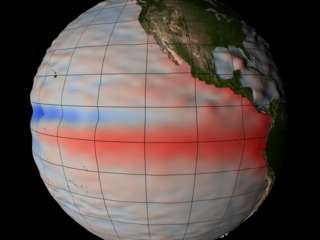
Ocean surface height is indicated by color: average (white), 20 inches above average (dark red), 20 inches below average (dark blue).
A range of differences in sea level can be seen in the waters surrounding Southeast Asia.
Depending on seasonal winds and rainfall, sea level can vary greatly in the Red Sea.
Water expands as it warms, causing sea level to rise. Above, the warm waters of the Gulf of Mexico create a distinct swell west of Florida.
This image shows Pacific Ocean sea levels during the 1997 El Nino, when westward flowing warm waters caused a tremendous swell across the equator.
Credits
Please give credit for this item to:
NASA's Goddard Space Flight Center
-
Animator
- Greg Shirah (NASA/GSFC)
-
Scientist
- Akiko Hayashi (NASA/JPL CalTech)
-
Writer
- Patrick Lynch (Wyle Information Systems)
Release date
This page was originally published on Thursday, May 9, 2013.
This page was last updated on Wednesday, May 3, 2023 at 1:52 PM EDT.
Related
- ID: 3206
 Visualization