GOES-R Series Resource Reel
The new generation GOES-R satellites will carry significant improvements and technology innovation on board. GOES-R will be able to deliver a full globe scan in only 5 minutes, compared to the 25 minutes needed for the same task with the current GOES satellites. GOES-R's lightning mapper instrument is expected to improve warning lead time for severe storms and tornadoes by 50%. This without a doubt will help predict severe weather in advance and save more lives. This reel is a compilation of finished productions about the GOES-R mission as well as supporting materials such as animations, visualizations, and still images.
Spacecraft Animations
GOES-R: Living With Space Weather
In addition to monitoring weather on Earth, the GOES-R satellites will monitor weather in space caused by electromagnetic radiation and charged particles released from solar storms on the Sun. Many people rely on space weather data, including pilots, farmers, satellite operators, electric power workers, and astronauts.
For complete transcript, click here.
The Geostationary Operational Environmental Satellites – R Series (GOES-R) is the next generation of geostationary weather satellites. The GOES-R series satellites will provide continuous imagery and atmospheric measurements of Earth’s Western Hemisphere and space weather monitoring to provide critical atmospheric, hydrologic, oceanic, climatic, solar and space data. This video is a short trailer that creates awareness about the upcoming GOES-R mission.
For complete transcript, click here.
ABI: The Future of Weather Monitoring
The Advanced Baseline Imager (ABI) is the primary sensor on the new generation GOES satellites, GOES-R. ABI will have 16 spectral bands, which will contribute to a greater number of products and better data quality. ABI will track and monitor cloud formation, atmospheric motion, convection monitoring, land surface temperature, ocean dynamics, flow of water, fire, smoke, volcanic ash plume, aerosols and air quality, as well as vegetation health. With 5 times faster coverage rate and 4 times better spatial resolution ABI is poised to become a true success story, benefitting the public by providing critical data.
For complete transcript, click here.
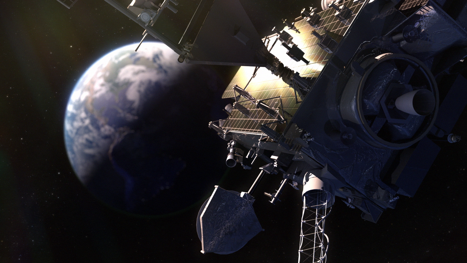
GOES-R Beauty Pass
An artist concept of the GOES-R spacecraft in geostationary orbit seeing lightning from space. One of the newest features of GOES-R is the critical ability to measure and see in-cloud lightning. Thus increasing the tornado warning time.
In this video severe storm researcher and engineer Tim Samaras talks about his view on tornadoes and what remains to be understood. He also covers the importance of satellite imagery to his research.
For complete transcript, click here.
This short video features highlights from a live Nationwide broadcast that took place on April 3, 2012 from the studio of NASA Goddard TV. NOAA's Deputy Administrator and Chief Scientist Dr. Kathryn Sullivan and Severe Storm Chaser and Engineer Tim Samaras talk about an important new satellite, GOES-R, that will be able to see tornadoes like never before.
For complete transcript, click here.
Tornado season began rather early in 2012. The GOES satellites send valuable data to help meteorologists stay a step ahead of severe storms. This video shows satellite imagery from the March 2-3, 2012 tornado outbreak that damaged severely Henryville, Indiana.
This narrated video presents high level goals and capabilites of the GOES-R spacecraft.
This is a narrated video presents high level goals and capabilites of the GOES-R spacecraft. This is the Spanish narrated version of the video.
The Geostationary Lightning Mapper (GLM). GLM will collect information such as the frequency, location and extent of lightning discharges to identify intensifying thunderstorms and tropical cyclones.
The GOES-R series satellites will provide continuous imagery and atmospheric measurements of Earth’s Western Hemisphere, total lightning data, and space weather monitoring to provide critical atmospheric, hydrologic, oceanic, climatic, solar and space data.
This short video describes the top level goals of the mission.
GOES-R will have a new instrument called Geostationary Lightning Mapper, or GLM. GLM will measure total lightning (in-cloud, cloud-to-cloud and cloud-to-ground) activity continuously over the Americas and adjacent ocean regions with near-uniform spatial resolution of approximately 10 km.
The GOES-R satellite will travel in space in a geosynchronous orbit, 22.300 miles above the equator. GOES-R will be called GOES-16 once on orbit and operational.
In addition to providing vital data for weather forecasts here on Earth, GOES-R will improve solar flare warnings for communications and navigation disruptions and enhance space weather monitoring.
Credits
Please give credit for this item to:
NASA/Goddard Space Flight Center, NOAA, Lockheed Martin
-
Animators
- Walt Feimer (HTSI)
- Chris Meaney (HTSI)
-
Video editors
- Silvia Stoyanova (USRA)
- Katrina Jackson (ARTS)
-
Interviewee
- Steven Goodman (NOAA)
-
Narration
- Lauren Gaches (NOAA)
-
Narrator
- Cory Powell (NASA/GSFC)
-
Producers
- Silvia Stoyanova (USRA)
- Katrina Jackson (ARTS)
-
Scientist
- Tim Schmit (NOAA/NESDIS)
-
Project support
- Swarupa Nune (Vantage)
- Katrina Jackson (ARTS)
-
Videographer
- Rob Andreoli (Advocates in Manpower Management, Inc.)
-
Writer
- Silvia Stoyanova (USRA)
Missions
This page is related to the following missions:Series
This page can be found in the following series:Related
- ID: 14601
![Music:"Fathoms” by Marc Aaron Jacobs [ASCAP]; ELIAS Music; Universal Production Music“Nova” by Lorenzo Castellarin [BMI]; Volta Music; Universal Production Music“Eye of the Sky” by Jonathan Elias [ASCAP] & David Ashok Ramani [ASCAP]; ELIAS Music; Universal Production Music“Recompense” by Marc Aaron Jacobs [ASCAP]; ELIAS Music; Universal Production Music“A Better Tomorrow” by Frederik Wiedmann [BMI]; Icon Trailer Music; Universal Production MusicComplete transcript available. This video can be freely shared and downloaded. While the video in its entirety can be shared without permission, some individual imagery provided by Artbeats, zefart/Pond5, sinenkiy/Pond5, and BlackBoxGuild/Pond5 through permission and may not be excised or remixed in other products. For more information on NASA’s media guidelines, visit https://www.nasa.gov/multimedia/guidelines/index.htmlComplete transcript available.](/vis/a010000/a014600/a014601/GOEStoGeoXO_YTThumbnail_NOAA.jpg) Produced Video
Produced Video - ID: 14602
- ID: 14073
![GOES-T Overview and Upcoming Launch Music: "Spacey Wave," by JC Lemay [SACEM]; Koka; Universal Production MusicAdditional footage provided by Lockheed Martin](/vis/a010000/a014000/a014073/GOEST_Overview_FINAL.01901_print.jpg) Produced Video
Produced Video - ID: 12863
Release date
This page was originally published on Thursday, May 29, 2014.
This page was last updated on Wednesday, May 3, 2023 at 1:50 PM EDT.