Eyjafjallajokull's Plume
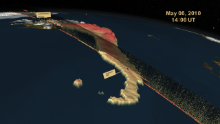
A silica-rich plume composed of ash, smoke and steam rose into the atmosphere over southern Iceland during the series of eruptions by Eyjafjallajokull volcano in spring 2010. Weary travelers were stranded at airports as air traffic across the Atlantic and over parts of Europe came to a halt. A European geostationary satellite, which orbits Earth above a single point, tracked the movement of the ash clouds as westerly winds carried them high above the ocean and toward northern Europe. Meanwhile, NASA's CALIPSO satellite measured the height and thickness of the material ejected into the atmosphere using its lidar instrument and infrared sensors. Together, the satellites created an unprecedented view of the eruption's aftermath. Watch the visualization below to see the movement and 3-D structure of the ash clouds released by Eyjafjallajokull volcano from May 6-8, 2010.

Satellites reveal how Iceland's ice-covered volcano wreaked havoc on Europe.
Dark orange areas represent volcanic ash traveling at an altitude higher than 4.3 miles (7 km).
Volcanic ash stands out against CALIPSO's speckled observations of more dispersed airborne particles.
CALIPSO spots ash particles over France on April 17, 2010.
A satellite captured this image of ash and steam billowing from Eyjafjallajokull volcano on May 2, 2010.
For More Information
See NASA.gov
Credits
Please give credit for this item to:
NASA's Goddard Space Flight Center
-
Animators
- Horace Mitchell (NASA/GSFC)
- Cindy Starr (Global Science and Technology, Inc.)
-
Video editor
- Victoria Weeks (HTSI)
-
Producer
- Michael Starobin (HTSI)
-
Scientists
- Charles Trepte (NASA/LaRC)
- Jason Trackett (SSAI)
- Michael J. Pavolonis (NOAA/NESDIS/STAR)
- Justin Sieglaff (Cooperative Institute for Meteorological Satellite Studies)
- Zhaoyan Liu (National Institute of Aerospace)
-
Writer
- Patrick Lynch (Wyle Information Systems)
Release date
This page was originally published on Tuesday, October 11, 2011.
This page was last updated on Wednesday, May 3, 2023 at 1:53 PM EDT.
Related
- ID: 3783